
Choose destination and profile
Pick Fastest (avoids unpaved), Shortest (fewest kilometres, gravel allowed), Adventure (well-driveable gravel) or Maximum Unpaved (as much as possible, difficulty aside).
The answer to legal off-road navigation
NavX4 finds as many unpaved roads as possible that map data says are open to your vehicle – and joins them into a real route. Not a track library, but navigation for 4x4s, overlanders and adventure bikes. Field-tested over more than 10,000 kilometres.
A clear answer
Yes: NavX4 was built for exactly that. It prioritises unpaved roads that the available map and access data says are open to the selected vehicle.
Satellite imagery does not tell you whether a farm track is open to motor vehicles, shared tracks get outdated, conventional routers lead straight back to the main road. Its own routing engine instead evaluates surface, road class, access rules, vehicle type, difficulty, barriers and closure reports – and builds one connected route out of them.
The honest limit: no app can guarantee the legal status of a road. Map data may be missing or outdated; signs, gates and instructions on the ground always take priority. NavX4 reduces guesswork – it does not replace looking through the windscreen.
Not just a collection of individual trails. NavX4 works as a 4x4 route planner, calculating a route through roads and tracks that fit your vehicle and the amount of adventure you want.
Pick Fastest (avoids unpaved), Shortest (fewest kilometres, gravel allowed), Adventure (well-driveable gravel) or Maximum Unpaved (as much as possible, difficulty aside).
Our routing engine considers surface, road type, mapped access rules and vehicle-specific restrictions.
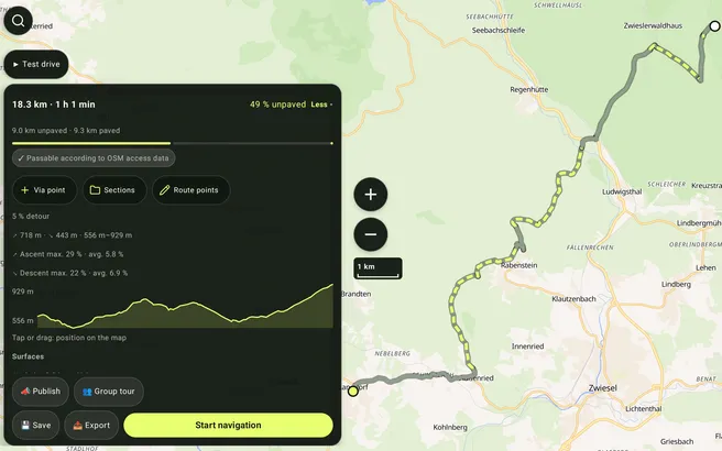
Compare the route, unpaved share and elevation. Navigate live or export GPX – while always respecting signs on the ground.
Legality without a false promise
NavX4 uses mapped access, vehicle class, road type and surface information. Roads with known restrictions are not treated as attractive shortcuts.
Since 18 September 2026 it calculates every route planned online, across Europe. Vehicle and permits are part of the question, the map is regularly brought up to date from OpenStreetMap overnight. Measured figures
Founder Amadeus Lederle has tested NavX4 over more than 10,000 kilometres. What is still missing is stated openly under status & roadmap, not in the small print.
No advertising, no passing on your routes. Only you see the driven line in your drive history, and it is deleted with the drive. Analytics only with your consent.
Important: No map knows every new gate or temporary closure. Signs, official restrictions and conditions on the ground always take priority – you remain responsible for your drive. See also the code of conduct for community tracks.
The Android app is NavX4: routing, navigation, offline maps, points, levels and drive history. In the browser you plan the same routes ahead – the drive happens with the app.
Self-hosted routing engine using OpenStreetMap and elevation data – since 18 September 2026 it calculates every route planned online. Gates and closures reported by the community feed into it.
In the app and in the browserFastest avoids unpaved ways, Shortest counts kilometres and allows gravel, Adventure looks for well-driveable gravel, Maximum Unpaved takes as much as it can – whatever the difficulty.
Fastest · Shortest · Adventure · UnpavedGPS position, turn instructions, remaining time, off-route detection and automatic rerouting in the Android app, on the car display with Android Auto as well – to try them out, in the browser too.
For the driveGermany, Austria, Switzerland, Czechia and Sweden – map and routing each. Out of reception the app calculates on the device with simpler data: no surface information, therefore no off-road points.
Android appAscent, descent, minimum and maximum at a glance. Import GPX tracks, export routes, switch to satellite imagery while planning.
For preparationPlan without signing in. A free account keeps routes across devices, and every credited drive lands in your drive history: time span, distance, unpaved kilometres, elevation, points and the driven line as a map only you can see. In the account on navx4.app and in the Android app.
Optional accountRoadbooks from PDF, GPX and OpenRally with a tulip roll, tripmaster and rally scoring, also generated from a route or track.
Manage and invite clubs, places and meet-ups of the community with filters, favourites and a meeting point by map pin.
Planner, driving screen and cockpit made for phone portrait and landscape, tablet and car display.
Group radio and help call over your own LoRa module, with no mobile network at all. We have not tested it on real radio hardware yet.
Approved tours and tracks that become verified after several real drives.
What works today, what is missing and what comes after: Status & roadmap.
Get the NavX4 app free on Google Play – or plan your first route straight in the browser. No login required: start, destination and a route profile are enough.
We cannot drive every farm track ourselves. Whether NavX4 is any good is decided out where you ride – and by what you send back to us. Closure reports, tracks and requests come from you; what gets asked for often moves up the list.
No account, no sign-in. Your report goes straight into the list we work from.
What drivers should know before planning their first NavX4 route.
No. Map and community data may be incomplete or outdated. NavX4 is a data-based planning tool, not legal permission. Signs, gates, property rights and conditions on the ground always take priority.
It depends on the country. In the UK only certain green lanes (byways open to all traffic) are legal for motor vehicles; in Germany many farm tracks are restricted to agricultural traffic. NavX4 evaluates mapped access rules and prefers unpaved roads the data says are open – signs on the ground always take priority.
Stay on permitted tracks. Leave no trace. Drive slowly and quietly near homes. Keep your distance from wildlife. The full code of conduct has a page of its own.
Yes, with the Android app: it downloads offline packs by region; Germany, Austria, Switzerland, Czechia and Sweden have both map and routing, so it calculates routes there without signal. More regions follow step by step. The planner in the browser, by contrast, needs an internet connection. Routes calculated offline carry no surface data, so they earn no off-road points – road kilometres still count.
Nothing. The Android app, the planner in the browser, offline packs, points, levels and drive history are free and will stay free. There is no subscription, no trial period and no feature that disappears behind a payment later. NavX4 is an alpha and lives on feedback from its community.
NavX4 is a one-person project. We do our best to fix bugs quickly, but we do not promise a fixed time. A report with the error log helps most: in the Android app you find “Report a problem” in the menu and under Settings → Help; there you can attach the cleaned app log and device details if you choose, and you see beforehand what will be sent. In the planner in the browser, “Report a problem” is in the menu as well. You then see status and reply under “My reports”.
Yes. Its routing profiles are designed for 4x4 vehicles, overlanders and adventure motorcycles. Choose between the truly shortest route and several levels of unpaved-road preference – making NavX4 a 4x4 route planner and an adventure-bike tour planner in one.
Street navigation mainly optimises time and distance. NavX4 can include road surfaces, track types and access information in its weighting, treating a high gravel share as a route objective of its own.
Yes. Planning and navigation work in the app and in the browser without an account. You only need one for personal features such as saving routes across devices, points, levels and drive history.
Yes. You can import existing GPX tracks for reference and export planned routes to compatible devices and apps.
Save or export the GPX file in NavX4 and choose a folder on your device in the Android file picker. Connect the device to your computer by USB, select File transfer on the phone and open that folder on the computer. You can then copy the GPX file. NavX4 uses the Android system file picker and needs no separate USB mode.
The Android app runs from Android 8.0 on 64-bit devices, from version 0.10.0 on 32-bit devices as well. Apart from a GPS receiver it needs no special sensor, no accessory at all. We keep no list of tested devices: on very old phones the map can stutter, and the app speaks only where a text-to-speech voice is installed. Something running badly on your device? Tell us, with the device name plus your Android version. What matters for phone, mount and power is on the help page “Device, mount, power”.
Every drive of 500 m or more guided by the NavX4 Android app earns points: 1 point per road kilometre, 30 points per off-road kilometre and 1 point per 10 metres of ascent. Only the ascent counts, never the descent. You reach Autofahrer at 1,000 points, Staubschnupperer at 5,000 and Steinesucher at 10,000 – below 1,000 the app honestly shows your progress instead of inventing a title. A free account is required, and a drive only counts with your consent to drive reports, which the app asks for before the first report. The version on Google Play since 13 October 2026 does not ask yet: its drives stay on the device until an update asks you, and drives older than 14 days by then no longer count.
Every credited drive lands in your account – with time span, duration, distance, unpaved kilometres, elevation and points, plus the driven line: the parts of the guided route you actually drove, simplified to about ten metres and without a timestamp per point. It makes unpaved kilometres count in full only the first time, and only you see it, as a map of the drive in your drive history; it is deleted with the drive. The history shows ascent and descent when the planned route carried elevation data. You find it in your account on navx4.app and in the Android app.
In the Android settings: Apps → NavX4 → Storage & cache → “Clear storage” (or long-press the app icon → App info → Storage). The app is then as on its first start: settings, cockpit profiles, recordings, offline maps and the sign-in are deleted. Uninstalling and reinstalling is not the same – Android may restore settings from the device backup (cockpit profiles, recordings and the sign-in are not part of it).
As soon as you sign in again: your saved routes and tracks including favourites and collections, your own places, your default vehicle, route profile and avoidances, the drive history with points and level, and everything you shared with the community. Only on the device, on the other hand, are cockpit profiles, settings such as units and language, recordings you have not uploaded, and the offline maps. So before resetting, open the app once while signed in and online so that routes and places changed on the road get uploaded, export recordings you want to keep as GPX, and download the offline maps again afterwards.
Through the form on this page – no account, no sign-in. An email address is optional; without one we cannot reply. With an account you report a bug in the app or the planner via “Report a problem” in the menu, with the error log if you choose. A wrongly mapped gate or barrier is best reported inside the app, where it attaches to that exact spot on the track. Email works too: info@iexlabs.com.
The Android app is free on Google Play, since 13 October 2026 with Android Auto, cockpit, drive history, community tracks, round trips and group rides with friends. Newer versions are in internal testing; which version is where right now is in the version list under Status & roadmap. iOS comes later.
Yes, since 13 October 2026 in the version on Google Play as well. On the car display the app shows the same map as on the phone, the next manoeuvre, remaining distance and arrival time, with the announcements coming through the car speakers; you can pick destination, route and profile in the car too. To be honest: so far we have only seen it in Google's test environment on a PC (Desktop Head Unit), not yet in a real car. Tell us if something does not fit in your car.